
![]()
Courtesy of the author - G TRESEDER
This article starts in the St. Just area, also has accounts of submarine mines outside the area The Wherry Mine (Penzance), Wheal Trewavas (between Marazion and Helston), Knockmahon in Ireland and Restronguet Tin Stream, (between Falmouth & Truro)l
Submarine Mines (by G. Treseder 1986 Eldon Pothole Club Journal Vol. 9 No 5).
----------------------------------------------------------------------------------------------
The undersea mining of a variety of minerals has been undertaken in many parts of the British Isles, the greatest concentration of such mines being found in west Cornwall. With respect to their working conditions some of these mines were no different to their land based counterparts, whilst in others those conditions betrayed their true submarine location.
When man first ventured below the ocean bed in search of metals is not known (1). Joseph Carne wrote in 1822 (2) that Botallack mine had been worked under the sea beyond the memory of any person then living. Metal ores exposed in coastal cliffs attracted attention from an early date and the method of their discovery is revealed in a report from the Mining Journal on Wheal Trewavas copper mine, which "...was first discovered from the sea by some of those amphibious creatures who obtain their livelihood by fishing in the summer and mining in the winter, who observed from their boats the lodes in the cliffs ... 11 (3)
Surprisingly the undersea tin and copper mines of the St. Just district of west Cornwall were dry compared to most land based mines elsewhere. At Levant in 1822 the water was drawn from the mine to adit by two men using a bucket. The mine was 42 fathoms below adit and much of it was beneath the sea bed (2). At Wheal Cock the miners did not appear to be greatly worried by the trifling amounts of salt water often entering their workings. Pryce writes in 1778 (4) that "at Huel Cock ..in one place they have barely four feet of stratum to preserve them from the raging sea, yet they have rarely more than a dribble of salt water, which they occasionally stop with oakum or clay, inserted in the crannies through which it issues."
It is recorded at a later date that a hole was drilled through the sea bed at Wheal Cock, the Atlantic Ocean was effectively kept out by means of a wooden plug. There are examples of mines in impervious rock where the cutting of some lodes, faults or cross-courses led to great influxes of salt water resulting in closure.
In workings beyond the shores in the St. Just area, the noise of the sea was clearly heard, and when visitors to them took flight it was a source of great amusement to the miners. However during storms they too had been known to flee, fearing the sea had burst in. To this day, (written 1986 Geevor’s pumps were switched off in 1991) Levant's Skip Shaft is inspected and maintained by Geevor, and the sea can be distinctly heard even in calm weather. Where the rock is softer, such as in the St. Ives district, the sea was only to be heard in rough weather.
To the miners, the presence of salt water and the roar of the waves just feet above their heads were merely irritations, although a continual reminder of the hazards of submarine mining. With a total disregard for common sense, greed often took miners too close to the sea and there are many instances of holes being made through the sea bed. When these were made above low water then repairs were often possible and work could resume otherwise loss ensued. There are surprisingly few references to the sea breaking into mines whilst the miners were at work and loss of life from this cause was rare. Nevertheless thirty six lives were lost when the sea broke into a coal mine at Workington (Cumbria) in 1837 (5).
Had the miners been given a free hand no doubt there would have been more accidents, as the agents often had to stop them from working too close to the sea bed. Carne provides an instance at Wheal Cock where "the miners followed a bunch of ore about 12 fathoms above the level, and would have pursued it still farther, had not the agents seen the danger and forbidden them.." The Mining Journal reporting on Wheal Trewavas (3), says the agents were "afraid of taking away too much of the backs for fear of an intruding visit from old Neptune."
The ultimate fate of Wheal Trewavas implies that greed did get the better of its miners and management. In June 1844 there was a false report circulating that the sea had broken into the mine and it would close (6). In fact it continued to work normally until May 1846 (7) when it was resolved at a meeting of the company that since all the ends had proved the lode to be poor in depth that the mine should be stopped immediately and the materials sold by auction, "taking away only such ore as will pay," implying the removal of rich ore such as is left in pillars, shafts and other places, the winning of which would have endangered or obstructed normal working. Combined with a report of 1837 this resolution may well have set the scene for the final curtain. In that year it had been reported that the 20 fathom level east of the Engine shaft had been stopped because it was too close to the sea despite being worth £30 to £40 per fathom (8). Whether removal of this ground resulted in the sea being breached is not known, there may even have been later workings (9).
The story of the inundation of Wheal Trewavas was told in 'Old Cornwall' in 1961 and although no dates or references to sources are given for the event, it makes an interesting tale. It happened the day that the tributers annual dinner was to take place with the meal quixotically served underground "well out under the seal'. Two men had gone underground to put the final touches to the tables of food ready for the dinner in the evening. One of them noticed some water issuing from the roof and dripping onto one of the tables. The two men made a hasty exit to the surface, and soon before the time planned for the dinner the sea had broken in leaving the dinner for the fishes. As the mine was irrevocably breached below low water all seaward work at this mine ceased henceforth.
At the Knockmahon Copper Mine, County Waterford, Ireland, accidental holings were made through the sea bed from stoping above the 16 fathom and 26 fathom levels on the Stage lode. Luckily these were situated above low water, so with difficulty and at great expense the sea was successfully dammed out and work continued (10). Since the Irish are often the subjects of unkind humour it is perhaps ironic that the reckless mode of working the deposit, so clearly depicted in the section, is probably attributable to Cornish rather than native miners. Carne (2) provides two examples of mines in the St. Just district where holes such as these were made in the ocean floor and similar successful repairs achieved. At Botallack he says " The ancient workmen ..followed the ore so high as to open a communication between the sea and the mine. Whether this opening was made whilst they were at work, or the sea afterwards broke through the thin barrier which was left, is not known; it is, however, now stopped by a wooden platform, on which is laid a mass of slimy turf, and the whole is covered by the stony fragments of the beach."
At Little Bounds "at some former period, through the avarice or carelessness of the workmen, a communication was made in two parts of the lode ... between the sea and the mine: one of them is about high water mark at spring tides; the other is covered by the sea at every tide, except at very low neaps: great and constant attention is therefore paid to the latter, which was at first stopped by a piece of wood covered with turf; but as this was found not to be perfectly secure, a thick platform, caulked like the deck of a ship, is now placed on it, which renders it almost water proof.."
Little Bounds was later included in the St. Just United Mine which worked the area until January 1889 (11), so no doubt this place was inspected and maintained up to that date. The Saveall's lode of Little Bounds is clearly visible in Priests cove as it runs along the granite killas junction, the position of the lower holing was discovered by the writer and was identified by a stream of salt water welling up from it.
The writer's investigations have revealed that the hole was made on the south or footwall side of the lode in an area of mineralised wall rocks, the quartz portion of the lode still being intact. Several pieces of timber have been found projecting from the boulder filled hole and on a protected ledge a piece of board was found still in place, its underside covered in slimes (clay). This suggests that the board was installed to protect from erosion by the sea, a plug of such slimes which sealed a wooden structure beneath it that formed the bulk of the repair to the breach. The supports of this structure were probably cross timbers resting in hitches cut into the solid rock. One hitch has been discovered by the writer on the north side of the hole and further investigation is planned for the future.
Carne also records that a holing was made at Wheal Hermon. This mine formerly known as Huel St. Just "furnishes another instance of the dangerous consequences of approaching too near to the sea, whilst in pursuit of the treasures of the earth- In one part of this mine, the sea broke into the cavity from which the lode had been taken away too near to the surface." Although Carne does not refer to the hole being sealed he states that the mine was soon to be re-opened.(12
It is said locally that the water never flowed out of the Levant adit after closure in 1930, the sea breaking in before the mine was totally flooded. At the neighbouring Geevor mine in the late 1950's exhaustion of the older parts resulted in development of new ground to the west towards the abandoned Levant mine. It soon became clear that Levant would have to be dewatered in order to secure the economic future of Geevor. This would provide safe access to the seaward extensions of the Geevor lodes coursing towards Levant and possible exploitation of unworked portions of Levant lodes, leading to longer term exploration of the area to the south towards Wheal Cock and Botallack.
Early investigations at Levant revealed that the water was rising and falling in sympathy with the tides indicating as had long been suspected that the sea had broken in. In 1960 the location of the breach was found using fluorescein introduced into Skip shaft- The dye took two days to appear, and revealed the -position about 60ft from the cliff, this was inspected by divers from Imperial College (13). The hole was found to correspond with stoping above the 40 fathom level, a notorious spot known as the 40 backs, which had caused anxiety since the 1860's. Thought was then given to overcoming the seemingly impossible task of effecting a repair in deep water. One early idea was to construct a sea wall to contain the breach area, this method had been used with success at the Hodbarrow Iron Mine, Cumberland (14). Given the nature of the sea conditions it was decided to seal the hole with concrete.
A 75ft ex-Admiralty motor fishing vessel had been purchased for the project and christened Wheal Geevor. Being based at Newlyn the boat's trip to Levant involved rounding Land's End with its cargo of materials necessary for the job in hand. That this should have included crab pots and other fishing tackle added an element of mystery to an already complex undertaking.
The first attempt to seal the breach with a concrete mat failed as insufficient attention had been paid to clearing the area around the hole. The remains of the concrete were blasted away as were the weak sides of the breach. The area around the holing was cleared by divers using air lifts, resulting in a cavity approximately 50 feet by 20 feet . Water was pumped from Skip shaft so as to draw loose sand and rock into the workings where it became compacted. Bags of cement were used to build a wall around the working area and grouting tubes inserted as deep as possible into the breach. An iron reinforcing framework was built over the hole, this preparatory work being completed in October 1965. Grout was pumped down the cliffs to the breach area and the pumps in Skip shaft were worked to assist the flow of grout into the boulder filled hole. Raw aggregate was dumped by barge onto the breach area and so layer by layer a plug was built up. Time was allowed for the concrete to cure then the water was lowered in Skip shaft, this time the repair was found to be making a good seal.
After a great deal of grouting underground into the area beneath the breach, the water being pumped from the mine was restored to the same quantities as when the mine last worked. A more detailed account of the operation can be found in a paper by Batchelor and Wardle presented to the Institute of Mining and Metallurgy (15). Despite copious technical detail concerning concrete and grouting techniques, the purpose of the crab pots remains conspicuously unexplained!!
No matter how seemingly unobtainable, when riches can be seen close to hand, eventually somebody will find a way to exploit them. More often than not such schemes highlight the fine dividing line between ingenuity and insanity, and this is certainly true in the case of the Wherry Mine at Penzance, and the alluvial tin workings beneath the estuary of the Carnon River.
John Hawkins predicted in 1818 (16) that as the more easily exploited land based deposits became exhausted then man would turn his attention to those deposits beneath the sea bed and at some distance from the land. He witnessed the beginnings of this process when he visited the Wherry Mine, this probably being the first attempt to sink a shaft on a piece of rock nearly always covered by the sea. Located on the foreshore between Penzance and Newlyn, the Wherry mine was principally a producer of tin although cobalt and uranium were known to occur. The deposit consists of a mineralised elvan dyke striking roughly north-east south-west and dipping south-easterly at 20-30 degrees, the dyke is just exposed at low tides on the Wherry rocks some distance from the shore. During its history of exploitation there were three periods of activity.
There was an initial primitive venture in which the richest ground was mined away in open-cast fashion between tides hence with limited success. This predated the second but most important development which commenced in about 1778 when a miner named Thomas Curtis embarked on an enterprise which undertook to sink a shaft on the rocks near the older workings. Initially he worked single handed, work only being possible during the summer and then restricted to about two hours at low water and much of this time being devoted to bailing out the workings. The site was covered by about 20ft of water at high tide. As a consequence a wooden turret was constructed around the shaft-collar to keep out the sea.
Production began after three summers of development, initially the ore was transported to the shore by boat. Work remained impracticable during the winter months. Although the turret kept out much of the water it was necessary to work between tides and much time was still being wasted at the start of the shift in bailing out the workings. In one part of the mine the ore body was stoped to within 3ft of the sea bed resulting in an increase in the water problem.
The enterprise was successful for many years. Curtis died in 1791 but the mine continued to be prosperous under local adventurers. An engine was erected on the shore and a bridge constructed to carry the pump rods out to the shaft, this also provided a walkway to barrow ore to the shore. There was a plan to sink a shaft on the land and drive a cross-cut out to the dyke but this did not materialise. The mine came to an abrupt halt in 1798 when an American vessel broke free from its moorings during a storm and demolished the turret around the shaft thus terminating the second development.
In the final initiative, in the 1830's a company was formed to rework the mine, it was not successful and stopped in 1840 (17). A similar venture was planned to work a lode on the foreshore near Long Rock, to the east of Penzance but the initial works were destroyed by the sea before the completion of a breakwater.(18)
Alluvial tin was found in many parts of Cornwall and has been exploited for thousands of years. The quality of this stream tin was usually superior to lode tin due to the oxidation and removal of contaminant sulphide minerals. Some of the most remarkable workings, both for value and mode of operation, were situated in the lower reaches of the Carnon River. The tin occurred as cassiterite in rounded water-worn fragments varying in size from sand to fairly large boulders. Owing to their high specific gravity these were found in a layer of gravel resting on bed-rock. The tin bed varied in thickness from just a few inches up to 6ft with an average of around 2ft, this being overlaid in the lower tidal areas by some 60ft of mud and covered by about 14ft of water at high tide.
Early methods of exploitation involved the construction of dams to keep back the salt water followed by the removal of the entire mud overburden revealing the thin band of rich gravel. Closer to the mouth of the estuary this method encountered limitations attributable to increases in both scale of works and tidal activity. In dam assisted operations of this kind, it must have been a great temptation to undermine the mud and remove the gravel for some distance around the extremities of the excavation. It is interesting to speculate on the likely techniques that yielding to the temptation could have produced and particularly whether such activity may indeed have been a precursor of the more sophisticated techniques known to have been employed subsequently at this location.
In the early 1800's underground methods were introduced to work the deposit. Shafts were sunk in the mud of the estuary, cased with timber down to bedrock and levels were driven, part being in rock and the rest in the gravel therefore requiring extensive timber support. The workings were drained by engines on the land, the pump rods being carried out to the shafts on tressels, in a similar manner to the Wherry mine. As the works progressed away from the shore severe power losses were being incurred owing to the greater mass of pump rods. To overcome this problem an artificial island was built out in the middle of the creek and a shaft of iron cylinders 12 feet in diameter sunk into the mud down to the gravel bed. A pumping engine was erected on the island and work continued satisfactorily. As the gravel was worked further away, more islands were built (19). At least three separate sites were worked by this broadly similar method, the most recent being the best documented (20).
The Restonguet Tin Stream Company (21) was formed in 1871 to exploit, by means of two shafts, a supposedly unworked section of the alluvials adjacent to Point between the old Upper and Lower Carnon Mines.
Sunk at a short distance below high water and dammed at the collar, Engine shaft (or Taylorls) was mined to a depth of 18 fathoms through solid rock. This shaft was vertical and had been sunk to provide about 30ft of such solid rock between the level and the tin bed. The levels of the earlier workings had not been sunk deep enough to drain undulations in the river bed which often contained the richest gravel.
The second shaft being the Iron shaft (or Charles') was sunk in the middle of the creek. Although its main function was for ventilation, at low water the miners could cross the mud and gain access to the workings via a ladder road.
Iron shaft consisted of cast iron cylinders 6ft long and 6ft in diameter with internal flanges, each length weighed about 2' tons. A stage was built and guides provided to position the cylinders correctly. The bottom of the first cylinder was sharpened to aid sinking and as it sank the core of mud was removed. Further sinking was achieved by the application of weights and at first a crab winch was used for this purpose but as more lengths were added, a girder was placed over the top of the cylinders and barges loaded with stones were attached to this girder by chains at high water. Hence, as the tide fell thus lowering the barges, their weight sank the cylinders after which further mud was removed and the cycle repeated. A weight of 250 tons was required to sink the shaft as it neared the tin bed. In all thirteen lengths were sunk leaving 8ft exposed above high water, of which 4ft was above the collar of the engine shaft thus providing natural ventilation.
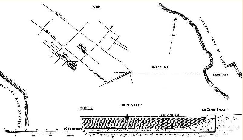
Engine shaft was commenced first and the iron shaft was sunk as the crosscut was driven under the creek towards it. By May 1872 the crosscut was out 55 fathoms and eight cylinders had been joined together. The crosscut was being driven at a larger than normal dimension, 5ft wide by 9ft high. In order to allow for a measure of water build up in the event of a prolonged pump stoppage, the track was laid 2 feet above the bottom of the level (22). Of all the water that entered these works the bulk came from the solid rock with comparatively little from the gravel.
In June the Iron shaft had reached the top of the gravel and was stopped there. The sides were timbered leaving openings east and west for driving in the tin bed and by August, the crosscut was out far enough to rise into the No.1 level in the tin bed, just east of the iron shaft. The rise was mined 9ft by 4ft and provided a pass for ore and a pass for waste, each of ten tons capacity. The rise was essential for ventilation and drainage, there was also a ladder-road built to provide access to the workings, this was used at high water when the tide prevented crossing over the mud by foot to the iron shaft. A second rise between the crosscut and No.2 Level was started late in 1872 mined 10 feet by 4 feet, and again having chutes for ore and waste, a third rise was mined before the mine closed.
Two main levels (No.1 & No.2), were driven north-westerly in the tin bed about 18 fathoms apart. The bottom part of these drives were cut out of bedrock and track was laid in both back to the rises. Heavy timbering was required in these main drives. Sets were built at intervals of 21 feet consisting of 8 inch square legs each 7 feet long, and resting on bedrock sloped inwards from 4 1/2 feet at the base to 2 feet at the top with a 10 in. cap piece. The top was covered with half logs, with 1 1/2 planking on the sides. At high tide the extra burden on the timber support was clearly discernible.
Drives were mined at right angles to the main 'Levels known as air levels (G on the plan). From the air levels the stripping levels (H) were mined parallel to the main levels and about 14 feet apart. Retreating from the extremities of the area to be stripped back towards the air level, the boards were removed from both sides of the timber sets which were 3 feet apart in these drives. The gravel was removed for a distance of 17 feet either side of the drive halfway to the next stripping level). Great care was taken to leave the mud in place and ensure that all the gravel was removed down to bed rock.
Working conditions varied greatly, where the gravel was thickest the miners worked standing up, whilst in the thinner parts they had to work lying down and sometimes had to cut away the bed rock to reach the gravel. As the stripping retreated to the next space the set between was removed and the timber recovered for, re-use. The mud was allowed to come down and fill up the space previously occupied by the gravel, there was no apparent increase in water entering the mine due to this process. The ore from the stripping operations was transported back to the main levels in barrows and transferred into wagons to be trammed back to the ore passes. The gravel was removed to within 30 ft of the main levels and 9ft of the air levels. Once all the stripping had been completed if the air level was no longer needed then this was stripped. The mining method chosen required a high proportion of development (over 20%) almost 100% recovery of the gravel was achievable.
The winding engine was being installed in February 1873, this was the first mine in Cornwall where the ore was hoisted to surface in wagons in a cage. The gravel was loaded via chutes into wagons in the crosscut and then trammed back to Engine shaft. In April 1873 the dressing machinery at surface was working although there was insufficient ore coming up from underground, a situation soon to be rectified by putting more men onto stripping the gravel.
The reports from the agent which appeared in the Mining Journal were never over enthusiastic about the value of the tin gravel usually describe as "fair quality.' The average grade is reported to have been about 1%, however this was very economically concentrated in jigs, to a nearly saleable quality, and was of course cheaper to work than lode tin. The reports also made frequent references to old workings, these must have been a source of considerable danger and it is likely that more of the gravel had been worked than had been anticipated. The tin had been worked out from both shores leaving an unworked strip about 18 fathoms wide in the centre of the creek. Another hazard was the presence of methane from the decaying organic matter, this had been ignited by the miners candles on a number of occasions. As if this was not trouble enough, when the gravel was being stripped the freshly exposed mud absorbed oxygen from the atmosphere sufficient to extinguish candles.
Despite the many innovative working methods the adventure attracted little attention in the Mining, Journal probably because it was a serious mining undertaking and not a share pushing exercise. Work had begun during a great tin boom with prices at record levels. The discovery of rich and easily worked deposits in Australia caused a dramatic turn around in the tin price, this coincided with "he mine starting to produce. Work was suspended early in 1874 and no doubt the venture would have been more successful in a better economic climate, however 'it is doubtful that much material remains unworked.
It is in the nature of the subject that exploring the records is less hazardous and more remunerative than exploring what they record. There is little of interest to be seen at any of the sites since all the mines mentioned are now flooded with the exception of Levant which is now part of the active (only just!) Geevor Mine. Hopefully those currently digging mines and caves will have found some interest and stimulation in these accounts of the Canute like activities of former generations of British miners.
Acknowledgments
The writer wishes to express his gratitude to Allan Reynolds for the map and
all the drawings, which were researched and prepared at short notice. Thanks
are also due to the following people who contributed to many helpful conversations
on the subject of submarine mining - David Clough, Mike Midgley, Elwyn and Carol
Rees, Allan Reynolds, Charles Smith, Jack Trembath, Jack Trounson and last but
not least my wife Delia.
References General Cornwall's Mines & Miners, A.K. Hamilton Jenkin, Vols 1 to 16 Abbreviations TRGSC Transactions of the Royal Geological Society of Cornwall M.J. Mining-Journal (1) Hawkins (16) mentions two references in classical history on submarine mining. (2) TRGSC Vol.2 (1822),,Joseph Carne, On the Mineral Production & Geology of the Parish of St. Just. (3) M.J. 17th October 1835. (4) Mineralogia Cornubiensis, William Pryce, 1778. (5) Coal & Coal Mining, Smyth, p50 (6) M.J. 1844 pp 223,2@1,237,233 (7) M.J. May 9th 1846 (8) M.J. May 13th 1837 (9) Not exhaustively researched. (10) TRGSC Vol.8 Pt.1, W.J. Henwood (11) St. Just Mining District, Cyril Noall, 197@ (12) Wheal Hermon was pumped successfully during the 1960's (Eldon Pothole Club Journal Illol 9 No.4 c).40) so if a holing was made it is probably located near high-water at spring tides. (13) Mining Magazine Feb.1961. (14) Cuiberland Iron, A.Harris, 1970. (15) Preprint of a paper to be discussed by the intitute of Mining and Metallurgy, 31st January 1969, Sealing of the Undersea Breach into Levant Tin Mine, Cornwall, by D.H.Batchelor and H.Wardle. (16) TRGSC vol1, Submarine Mines, John Hawkins, 181,,,p. (17) The account of the Wherry Mine was compiled using Mines and Miners of Cornwall No. 4, A. K. Hamilton Jenkin; TRGSC Vol. 1 Submarine Mines, John Hawkins; The Mineralogical Magazine June 1949, The Wherry Mine, Sir Arthur Russell Bart. , (R.Sambrock's 'The Wherry Mine British Mining No. 19 ( 1980-82), is more easily obtainable and an almost identical copy of Sir Arthur Russell's paper.) (18) Mines and Miners of Cornwall No.11, A.K.Hamiltor, Jenkin (19) Observations on Certain Tin Stream Works in the County of Cornwall - George Henwood. (20) Proceedings of the Institute of Mechanical Engineers 1873, Description of the Tin Stream Works in Restronguet Creek, Charles D.Taylor; Reports from M.J. Feb 1872 - Feb 1874 (21) Probably a subsidiary of Joliri Taylor & Son. (22) Driving at this dii.@-lensi,on incurred extra cost and the advantage would soon have been lost due to the gradient of the drive. As the cross-cut was developed further it is likely that they reverted to a more economical dimension.
.......... for a 'feel' of the mines - Read "Riding the Engine" http://www.tinmining.co.uk/penhale.htm
..... watch "Riding the engine http://www.tinmining.co.uk/private.htm"